
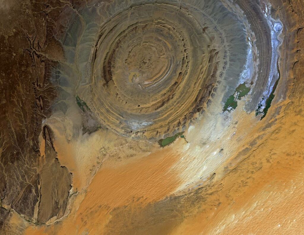
The Richat structure, popularly known as the eye of the Sahara, is a striking, symmetrical, slightly elliptical geologic feature. It has concentric rings and measures about 25 miles (40 kilometers). This unique geologic feature visible from space is in central-west Mauritania’s Sahara Desert.
What is it? The Richat structure is a deeply eroded, sunken dome of late Proterozoic and Paleozoic sedimentary rocks. Due to differential erosion and lithology, it shows uniquely contrasting intrusive igneous rocks and siliceous megabreccia.
Local tribes probably saw it first, with the earliest descriptions by geologists seen by the 1930s, but it was too expansive to visualize its appearance. However, during the Gemini 4 Space mission in July 1965, astronauts James McDivitt and Ed White accidentally noticed or discovered this spectacular feature from space as they were orbiting the Earth on top of North Africa.
Later, the Landsat satellite took photos, giving information about the Richat structure size, height, extent, landscapes, etc. To date, it remains a major attraction, wonder, and landmark guide to the space shuttle or crew. Did you know that it has inspired even conspiracists seeking to unearth the location of the lost city of Atlantis?
What is the Richat structure or eye of the Sahara? What is it made of, and how did it form? Can you tour the area to see it? Is it the lost city of Atlantis? Get answers to all these questions and a lot more.
Facts in brief
- Name: Richat Structure (Guelb er Richât or Qalb ar-Rīšāt)
- Other common names: The Eye of the Sahara, Blue Eye of the Sahara, Earth’s Eye or Eye of Africa, Eye of Mauritania, and Bull’s Eye of the Sahara.
- Age: About 100Ma during Pangaea supercontinent split of Africa and South America forming the Atlantic Ocean.
- What is it: Circular geological feature measuring 25 miles (40 kilometers) in diameter with concentric rings surrounded by a plateau and large dune fields (Erg Oudane) formed from the erosion of symmetrical anticline dome showing its original flat or horizontal rock layers. It is not manmade or the lost city of Atlantis.
- Location: Northwestern Taoudeni Basin, Central Adrar Plateau, west-central Mauritania in the Sahara Desert near Ouadane
- Coordinates of Google Earth or Google Maps: 21°06′ 52.40″N, 11°23′ 39.40″W.
- Recognition: The International Union of Geological Science (IUGS) 2022 recognized the Richat structure as one of the first 100 geological heritage sites with the highest scientific value.
- Threats: Its location in an inhospitable desert presents little threat to human or animal activities. However, continued desertification may result in the burial of this landmark.
What is the Eye of Sahara
The Richat structure, or Eye of the Sahara, is a massive, highly symmetrical, slightly elliptical geologic feature or landmark with concentric ridges measuring about 25 miles (40 km) that appears slightly sunken compared to surrounding Adrar plateau bedrock or landscapes. It is in Taoudeni basin’s northwestern area of the Sahara desert’s Adrar plateau in west-central Mauritania, with Ouadane the closed town to the southwestern part.
Richat structure is visible from space due to its large size and absence of vegetables, and it resembles an eye, especially an ox’s or bull’s eye. Some people describe its ridges as half-cut onion-like layers or an outsized ammonite fossil in the Sahara Desert.
The eye of the Sahara is the largest, symmetrical, and deeply eroded ridged geologic feature that is slightly recessed compared to the surrounding Adrar plateau bedrock or landscapes. It has late Proterozoic sedimentary on the inner part and Paleozoic sandstones on the outer parts intruded by volcanic and intrusive igneous rocks and siliceous megabreccia. Also, it has faults in its periphery.
Initially, it was thought to have formed from a giant meteor impact like Wolfe Creek in Australia or Barringer Crater, Arizona, USA. Geologic studies concluded it was not and not astroblemes but endogenic.
A possible explanation for its formation is a symmetrical dome that underwent piston-like collapse of the inner part followed by millions of years of sculpturing due to differential erosion of resistant quartzite and soft rocks, creating circular high-relief ridges or cuestas.
Photos and images from space
There are many images of the Richat structure from the Landsat satellite. They will show contrasting colors to distinguish vegetation, bedrock (sedimentary, volcanic, and intrusive igneous rocks and sand on exposed landscapes and this structure. Some colorations may be false but serve the same purpose.
Contrasting colors are due to the different lithologies or physical appearance (color, composition, grain size, texture, etc.) of the rocks in the structure. On the other hand, the circular ridges and ruggedness of the surface are due to differential erosion rates.


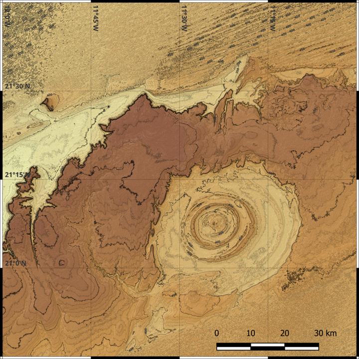
Richat structure on a Map
Below is a simple topographic map of the eye of the Sahara.
The U.S. Geological Survey has a geologic map of Mauritania that clearly shows the eye of the Sahara and gives detail on various rock formations, subgroups, groups, etc., for the country. It has a PDF legend and two maps.
Here is a video on the map.
Petrology or Rocks
The Eye of the Sahara has late Proterozoic eon (ended about 541 mya) sedimentary rocks in its center and Ordovician period(488.3 – 443.7 mya) sandstones characteristic of the on its outer edge characteristic of the Taoudeni basin.
These rocks dip 10-20 degrees outward with concentric high-relief ridges. They are intruded by magmatic intrusive and extrusive rocks like gabbro, rhyolite, carbonatite, and kimberlite with siliceous megabreccia at the center.
Besides Proterozoic to Ordovician sedimentary rocks, the petrology of the Richat structure complex is as follows:
- Rhyolite: Rhyolite (and all volcanic rocks) occurs in the inner part, i.e., inside the innermost concentric ridge. They are lava flows and volcanic pyroclastic (hydrothermally altered tuffaceous) rocks associated with two phreatic eruption centers or maars.
- Gabbro: Gabbro forms two concentric rings or circular dikes, with the inner about 20 meters in thickness and about 3km from the center of the dome. The other is at 7-8 km from the center and is 50 meters thick. They formed as basaltic magma pushed through concentric fractures, forming circular dikes.
- Carbonatite (≈ 99± 5 Ma): The dome has 32 mostly vesicle-devoid massive carbonatite intrusions, mainly dikes (1-4 meters thick and 300 meters long) oriented N15-20 degrees and a few sills. They originate 30km below the Earth’s Surface and may have rare earth metals.
- Kimberlite (≈ 99 Ma): Kimberlites form several highly altered sills, one non-outcropping plug, and dikes on the northern part of the structure.
- Breccia (≈98.2 ± 2.6 Ma): The central part of the dome has siliceous megabreccia over 3 kilometers in diameter and 40 meters thick within the Paleozoic dolomite-limestone shelf.
The presence of intrusive and extrusive igneous rocks indicates a large, alkaline, cretaceous age igneous complex beneath the Richat structure, i.e., formed from a large alkaline magmatic intrusion.
How did the eye of the Sahara form?
The Richat structure was first described as a Richât crater or buttonhole in the 1930s-1940s, with Richard-Molard (1948) concluding its formation was due to a laccolithic uplift. The discovery of Aouelloul, Temimichat-Ghallaman, and Tenoumer impact craters during the 1952 geological expedition in Mauritania led to the conclusion that the Richat structure formed from a meteor impact.
However, structure and petrographic studies in the 1950s and 1960s didn’t prove it was an astrobleme. No evidence of hypervelocity meteor impact, including shock metamorphism (melted rocks) or deformation. Even the initial samples of coesite that would suggest shock metamorphism were a misidentification.
1. Earlier symmetric dome erosion theory
A common explanation of how the Eye of the Sahara formed is a result of the erosion of the symmetrical uplift or anticline dome. A huge bulb-like magma intrusion forced overlaying sedimentary rocks to curve, creating a dome-like structure with some fracturing on the edges, seen as faults on the periphery edges.
Afterward, volcanic activities died, and millions of years of water and wind erosion exposed the rocks that were originally flat before the uplift and gave the Richat’s structure a sunken appearance. However, since they had different hardness, the erosion occurred at different rates, resulting in concentric ridges or rings.
Are you surprised by water erosion when the Sahara is a desert? Don’t. It used to have temperature weather with rainfall, lakes, and rivers.
2. Guillaume Matton, Michel Jébrak theory
A recent theory states that the Richat structure formed around 100Ma as the Pangea subcontinent separated, creating Africa, South America, and the Atlantic Ocean. Lithostratigraphy correlation has shown it. During this plate tectonic movement process, massive volcanic activities involved a Cretaceous age complex of alkaline igneous magma.
Before 100 Ma, a large magma body began rising in the crust following preexisting crust weakness, forming a dome, propagating concentric fractures, and creating a magma chamber. Increased pressure forced some basaltic magma along concentric fractures but didn’t enrich the surface, forming the gabbroic ring dikes.
At approximately 100 Ma, kimberlitic and carbonatitic magma rapidly rose from deep in the crust through reactivated aulacogen, cross-cutting concentric gabbro dikes. Also, there was crust fusion, and magma differentiation started.
Hydrothermal fluids formed from the magma chamber and rose through the dome’s fractured and permeable middle part, dissolving limestone and causing hydrothermal karst-collapse megabreccia.
Shortly after 100 Ma, rhyolitic magma rises through conical fractures causing a violent phreatic volcanic explosion due to the interaction of magma with caldera lake water. This formed the two Southwest and Northwest two eruptive centers or maars in the inner part, and the process reopened the ring fractures that caused a piston-like collapse of the inner part.
Differential erosion over millions due to varying rock hardness resulted in the ridged appearance. However, the piston-like collapse preserved the middle part with volcanic rocks and hydrothermal karts in filling.
Touring the Eye of Sahara
You can visit the Richat structure location for tourism, geological, or archaeological studies. However, being expansive, you may not have a good visible impression. Also, being in a desert, conditions are extreme and sandy. So, don’t expect a luxurious trip.
You need a visa, if required, depending on your citizenship, a local sponsor, and an experienced tour guide or a driver who knows where it is. The closest airport is the Atar International Airport, and you can use automobile transport to Ouadane. Ouadane is a millennium-old UNESCO World Heritage Site on the edge of the Adrar Plateau, i.e., the western edge of the Sahara Desert, with about 4000 inhabitants. You will find a hotel or accommodation here.
Once in Ouadane, you can use a good-conditioned 4×4 jeep or go for a hot air balloon or an airplane ride for a bird’s view, but it will cost you more. There is no restriction, but you should visit during the day.
Besides this structure, you can also visit some tourist attractions nearby, including Ben Amera, Terjit, Diawling National Park, Chinguetti Mosque, and Banc d’Arguin National Park.
Is Mauritania’s Richat structure the lost city of Atlantis?
Many conspiracists and documentaries, including Jimmy Corsetti of Bright Insight, have attempted to link the Richat structure with the lost city of Atlantis ruins, described by Plato in 360 BCE. Plato described Atlantis with circles dividing land and water, i.e., concentric rings and Richat structure may appear as ruins.
However, no reliable or concrete scientific evidence has confirmed that the Eye of the Sahara is the lost city of Atlantis or it is a man-made feature. Except for the few Acheulian artifacts associated with Homo erectus on the out ring, archeologists have no evidence of the civilization described, including canals. Also, historians don’t seem to agree whether Atlantis was a historical place or mythological.
References
- Matton, G., & Jébrak, M. (2014). The “eye of Africa” (Richat Dome, Mauritania): An isolated cretaceous alkaline–hydrothermal complex. Journal of African Earth Sciences, 97, 109–124. https://doi.org/10.1016/j.jafrearsci.2014.04.006
- Abdeina, E. H., Bazin, S., Chazot, G., Bertrand, H., Le Gall, B., Youbi, N., Sabar, M. S., Bensalah, M. K., & Boumehdi, M. A. (2021). Geophysical modelling of the deep structure of the Richat Magmatic Intrusion (northern Mauritania): Insights into its kinematics of emplacement. Arabian Journal of Geosciences, 14(22). https://doi.org/10.1007/s12517-021-08734-4
- Richard-Molard, J. (1948). The Richât Buttonhole in Mauritanian Adrar. Comptes Rendus de l’Académie des Sciences, 227, 142-143.
- Cailleux, A. 1962: El Richat: dôme arasé, surbaissé ou cratère bombé? Notes Africaines, 93, 27-29
- Fudali, R. F. (1969). Coesite from the Richat Dome, Mauritania: A misidentification. Science, 166(3902), 228–230. https://doi.org/10.1126/science.166.3902.228
- Dietz, R. S., Fudali, R., & Cassidy, W. (1969). Richat and Semsiyat domes (Mauritania): Not astroblemes. Geological Society of America Bulletin, 80(7), 1367. https://doi.org/10.1130/0016-7606(1969)80[1367:rasdmn]2.0.co;2
- Communications and Publishing (2013, March 3). EarthView–Eye of the Sahara. USGS. https://www.usgs.gov/news/science-snippet/earthview-eye-sahara.
- NASA Earth Observatory. (2020, July 10). The Eye of the Sahara. NASA. https://earthobservatory.nasa.gov/images/150060/the-eye-of-sahara.
- The European Space Agency. (2004, November 12). The Richat Structure, Mauritania. ESA. https://www.esa.int/Applications/Observing_the_Earth/The_Richat_structure_Mauritania
- Robertson, E. (2014, July 7). Eye of the Sahara. EGU Blogs. https://blogs.egu.eu/network/bar/tag/eye-of-the-sahara/