
Unconformity in geology or Earth Science refers to a buried erosional and/or non-deposition surface separating lower older rock mass/strata and the younger upper one with a significant geologic record or hiatus gap.
The process that could form uniformity is the erosion of exposed rocks or a period with no deposition followed by new sedimentation and lithification to create the younger overlaying rock strata. Things like land uplift due to tectonic activities or fall in the sea level can result in erosion or a period of no deposition. In contrast, land subsidence or rising sea level will cause deposition.
Learn about unconformities, including historical background, meaning, formation, and significance or importance. We will also give you the common types of unconformities and a lot more.

Historical background and conceptualization
James Hutton (1787-1788) postulated unconformity. It is after observing angular unconformity at the Isle of Arran and later at Jedburgh and Siccar Point.
Hutton noted some surficial sedimentary features, such as ripple marks on inclined or vertical strata, and he was convinced they were originally horizontal on the sea floor. Then they must have tilted, been exposed to the surface, and eroded. Later, they submerged for the younger sedimentary rock layers deposition.
Back then, James Hutton did not use the term unconformity. He instead was descriptive with the expression ‘conjunction of vertical and horizontal strata’ part of his description.
However, before that, Nicholas Steno and John Strachey sketched angular unconformity in 1669 and 1719 had made sketches. Also, Jean Ettiene Guettard represented it on a geologic map in 1776. Unfortunately, they didn’t make much sense.
Later, Robert Jameson applied the term unconformity to describe what Hutton found. However, it remained unpopular until the frantic efforts of Henry De la Beche and Charles Lyell popularized the term. However, back then, it meant only angular unconformity. Clarence Dutton
It was not until the early 20th century that the term unconformity meant various types, not just angular. Some key contributors included Amadeus William Grabau, Eliot Blackwelde, and Bailey Willis.
Lastly, James Hutton also developed the uniformitarianism principle or Doctrine of Uniformity. Many consider him one of the fathers of modern Geology.
Understanding unconformity
Unconformities represent a gap in the geologic record. What does it mean, and how does it form? Let us explore together.
1. Geologic time scale
To help you understand unconformity, we need to talk about the geologic or geological time scale (GTS). The geological time scale represents time not based on the Gregorian 365-day-per-year calendar but on Earth’s rock records, i.e., a history of past rock layers.
However, events like erosion of existing rocks and/or deposition ceasing may result in a period with no rock layer record. For instance, weathering and erosion will destroy the geologic history (removes what already exists), while cessation of deposition will prevent time recording.
You should know that deposition is one of the three geologic contacts, the others being intrusive and fault contacts. It occurs nearly parallel and nearly horizontally (principle of original horizontally).
We call it conformable when the deposition is continuous without a significant geologic gap. However, we have unconformable contact if the time gap is substantial. It happens due to erosion of existing strata, cessation of deposition, or both and represents an unconformity.
2. What is an unconformity in geology?
Unconformities refer to buried non-depositional and/or erosional surfaces between rock strata or sequences of different ages. These unconformities represent an interruption or discontinuity in the geologic record, i.e., gap, i.e., a hiatus, and can be regional or local.
A hiatus is a geologic record gap between the lower old strata formed before erosion or deposition ceased and the younger above strata formed when a new deposition begins again. You cannot know geologic events during the hiatus, i.e., no rock record, and it can last for thousands to billions of years.
However, not every erosional or non-deposition surface is an unconformity. It must have a significant or measurable gap in the geologic record. Otherwise, you will have a diastem, a short deposition interruption with little or no erosion before sediments continue to deposit. You cannot use such to establish unconformity-bounded units.
Unconformity-bounded units are rock bodies below and above the significant unconformity. These rocks above or below an unconformity can be any or different kinds. However, their fossil or chronostratigraphic span and lithology should be enough only to help us identify the bounding unconformities.
Here is a video to further explain unconformity to you.
This one will help you too.
3. What causes unconformity?
The main cause of unconformity is the erosion of exposed rock layers or masses, followed by sediment deposition to create the younger rock strata. However, it may happen when no sediment deposition occurs, sometimes with some erosion. Afterward, there will be deposition again of the younger rock mass.
Also, some cases of subsidence, such as water dissolving carbonate rock layers beneath or sediment deformation, including due to tectonic movements, are possible but uncommon causes.
4. How do unconformities form?
Unconformities form mainly on sedimentary rocks or between sedimentary and other rock types (metamorphic or plutonic). However, it can occur in layered volcanic (pyroclastic deposits and lava flows).
The main driving force is erosion and sometimes cessation of deposition followed by an episode of sedimentation to form younger strata.
Surface erosion occurs due to sea-level fall or an uplift, including regression exposes rocks to erosion. For instance, tectonics may uplift, deform, fold, or fault regions, exposing them to millions of years of erosion.
On the other hand, deposition occurs under the sea, including in the case of transgression and rising sea levels, covering existing strata. Also, erosion may plane the initially exposed surface, taking it underwater. However, deposition can occur on land but is not a common cause of unconformities.
For instance, sequence stratigraphy has shown that the Paleozoic Era had many transgressions and regressions due to global sea levels and rise. It led to the formation of many globally acknowledged unconformity-bounded sequences.
However, unconformities can happen in submarine or ocean environments. For instance, mass movement, turbidity or thermohaline currents, storms, carbonate dissolution, transgression, and carbonate shelve clastic influx can cause erosion in the submarine environment.
5. How to recognize unconformities
You can see unconformities on outcrop rocks, road cuts, cliffs, quarries, or riverbanks. Some are easy to notice, such as the angular, while others are difficult to spot.
Ways to recognize subaerial unconformities include:
- Discordance of dip, i.e., the older rock strata dip at a different angle than the younger one.
- Fossil soils
- Paleosol (fossil soils) form from weathering before the new strata sequence and duricrusts.
- basal conglomerate or clasts of rocks under conformity
- Fossil age discordance or gap in fossil index can show an unconformity.
- Channels and scour marks.
- Paleokarts (casts buried by younger rocks)
- Presence of continental deposits
In the case of marine unconformities, evidence will be mass movement deposits, manganese nodules, and glauconitic minerals.
Lastly, on geological maps, unconformities will appear as contact lines, different from the ones used in other contact types. For angular unconformity, the contact lines will have different dips and strikes.
What is the importance or significance of unconformities?
Understanding what unconformities are, their types, how they form, and identifying where they occur is important in these ways:
1. Understand past geological history
It can help geologists reconstruct past significant events such as tectonic activities (like mountain building, faulting, folding, etc.), metamorphism, igneous activities, sea level changes, climate, soils (from paleosols in channels), etc. All this will give a glimpse into the past geological history and the forces influencing it.
Secondly, geologists, stratigraphers, and paleontologists must understand unconformities and identify disconformities correctly. Why? Because they will help to determine relative fossil age and past events accurately, considering they represent a hiatus.
2. Exploration of minerals and other resources
Unconformities are important in mineral, oil, and underground water exploration. For instance, they may mark times for decreased or increased porosity, affecting fluid migration in a rock mass. Therefore, unconformities can trap oil, create water aquifers, and are associated with uranium, gold, aluminum, and phosphate minerals. An example is Carlin Unconformity, which is associated with gold and silver.
3. Identify potential geologic hazards
You will know potential geologic hazards, such as some minerals in underground water associated with a certain unconformity. This knowledge can help you understand how it may affect health.
Types of unconformities
The three main or common types of unconformities are angular, disconformity, and nonconformity. However, there are others, such as blended, paraconformity, and buttress.
Here are the different types of unconformities with images or diagrams:
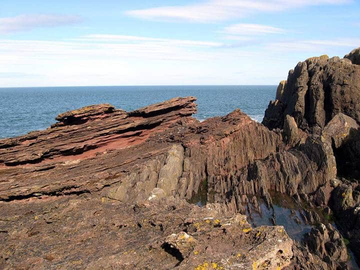
1. Angular unconformity
An angular unconformity is a type of unconformity where younger upper and older rock strata lie at different angles. It separates younger flat rock strata from eroded, truncated, tilted, folded, or deformed older rock beds.
Angular unconformities are easy to identify due to the strata with different strikes, dips, or both strikes and dips. They indicate tectonic activities (folding or tilting) and uplift after the formation of the old rock strata. Afterward, erosion planed down the tilted or folded edges before deposition of the younger strata.

2. Nonconformity
A nonconformity in geology is an unconformity between younger top sedimentary rock strata and older lower intrusive igneous or metamorphic rocks. This contact occurs where younger sedimentary rock beds overlie older eroded crystalline plutonic or metamorphic rocks.
Nonconformities are easier to identify since it involves different rock types. Therefore, you will easily notice differences in lithologies. Also, they usually have a large rock record gap.

Another example is Tirupati Eparchaean Unconformity in India, where Cudappah Supergroup 1600 Ma overlies 2100 Ma Archean granite and gneisses rocks and a dolerite dyke.
3. Disconformity
A disconformity is a buried erosional or non-depositional surface separating parallel rock strata of different ages with visible, irregular, or uneven erosional surfaces. The rock beds between the unconformity have the same orientation and discernable erosional features.
To identify disconformities, look at reliefs, solution features, stream channels, soil horizons, weathering profiles, etc. Also, they may have missing or large rock strata break between layers with different ages.

4. Paraconformity
A paraconformity is a type of unconformity with parallel rock beds or strata that don’t have discernable erosional features at the contact plane. It is a type of disconformity where the older and younger beds don’t have visible erosional features, making non-deposition a likely reason for its formation.
Paraconformities are the hardest to identify unless you use fossil records, and sometimes, they are known as pseudoconformities or non-depositional unconformities.

5. On lap or buttress unconformity
Buttress or onlap unconformity occurs when an unconformity surface appears to truncate younger sediments. This truncation happens when there is a substantial old strata topography.
A perfect example is having an island with old rock strata in a shallow sea. As the island subsides or the sea rises, successive young sediment deposition will occur. Each new layer will truncate at the island’s edge, i.e., on the unconformity surface until the whole island submerges. We call this kind of unconformity onlap or buttress.
The orientation of the old island rock strata may be parallel to the surface or not. Even when not horizontal, it is not similar to angular as younger strata truncate on older, i.e., on the unconformity plane.

6. Blended unconformity
Blended unconformity occurs when no clear contact plane or surface separates the upper younger and lower older layer on either a disconformity or nonconformity. Sometimes, the contact plane may have soils, pebble beds, or paleosoils with some grading to the lower layer and incorporated into the upper younger.
Usually, it is hard to show blended unconformity on cross-section diagrams. Why? Because there is no distinctive plane or unconformable surface.
References
- Van Der Pluijm, B.A., & Marshak, S. (2004). Earth structure: An introduction to structural geology and Tectonics. W.W. Norton.
- Plummer, C. C., Carlson, D. H., & Hammersley, L. (2016). Physical Geology (15th ed.). McGraw-Hill Education.
- Boggs, S. (2014). Principles of Sedimentology and stratigraphy (5th ed.). Pearson Education.
- Kusky, T. M., & Cullen, K. E. (2010). Encyclopedia of earth and space science. Facts on File.
- Shanmugam, G. (1988). Origin, Recognition, and Importance of Erosional Unconformities in Sedimentary Basins. In Kleinspehn, K. L., Paola, C. (eds). New perspectives in basin analysis (pp. 83–109). Springer, New York. https://doi.org/10.1007/978-1-4612-3788-4
- Tarbuck, E. J., Lutgens, F. K., & Tasa, D. (2017). Earth: An introduction to physical geology (12th ed.). Pearson.
- Van Der Pluijm, B.A., & Marshak, S. (2004). Earth structure: An introduction to structural geology and Tectonics. W.W. Norton.
- Schieber. J. (n.d.). Unconformities. Indiana University. Retrieved March 1, 2023, from https://geol105b.sitehost.iu.edu/images/gaia_chapter_6/unconformities.htm.
- Piller, W. E, Aubry, M. (n.d.) International Stratigraphic Guide – An abridged version. https://stratigraphy.org/guide/index.html