
Littoral cones are small, conical, rootless hydrovolcanic landforms.
We call them rootless together with hornitos because they don’t have vents connecting them to magma chambers deep beneath the Earth’s surface.
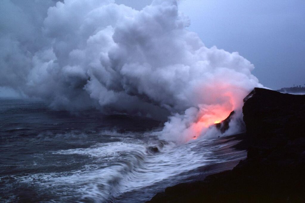
Littoral cones form at the point where lava enters the sea and other water bodies. Also, they can form where lava flows over ice or wet sediments.
The interaction between molten lava and water or ice will cause localized steam explosions or phreatomagmatic eruptions. These eruptions will fragment, eject, and emplace volcanic ash, lapilli, lava bombs, and other debris.
The ejected materials are called tephra or pyroclasts. They will later fall around the somewhat wide explosion center or pseudocraters.
The accumulation of these unconsolidated tephra or pyroclasts is what forms littoral cones. However, the warm, wet basaltic glass will be converted to palagonite, resulting in some cementation.
Lastly, littoral comes from the Latin word litoralis, which means seashore. These volcanic edifices use the name littoral since they commonly occur at seashores in coastal areas.
Littoral cones commonly form on seashores where water enters the sea or ocean. Photo credit: T.J. Takahashi, Public domain, via Wikimedia Commons.
Description and characteristics
Littoral cones are small, full to semi-circular or crescent-shaped volcanic landforms with wide pseudocraters. However, reconstructed ones may miss the crater.
Also, most have only a few segments, i.e., they don’t form complete cones or are breached in the direction of lava flow.
Such appears like a crescent-shaped ridge and commonly occurs where explosion centers are near the shoreline. Half the material will be in the sea, leaving half the cone on land.
However, some are complete, especially those that form on lava tube-fed pahoehoe lava flow.
Usually, littoral cones are tens of meters high and up to hundreds of meters wide. Most are less than 75 meters tall and 800 meters wide at their base. However, some are up to 100 meters high.
Their inner slopes are steep and often show truncated strata. In contrast, outer slopes are gentle, dipping at angles less than 25° and merging with underlying terrain at their base.
Littoral cones are unconsolidated and have various debris, including lava spatter, lapilli, volcanic bombs, or ash. Also, they may have some marine, lacustrine, or glacial sediments.
Those that form as lava flows into oceans or seas will have lava delta and hyaloclastite piles on their bases. Hyaloclastites form as lava spalls during rapid quenching in water.
Furthermore, if the lava supply is continuous and water episodic, you expect these cones to have alternating layers.
One layer will have pyroclastic breccia with mostly chilled blocky lava fragments mixed with marine, glacial, or lacustrine sediments, and the other one will have lapilli and bombs with fluidal shapes formed from pure lava spattering.
Yes. Some may resemble spatter cones or cinder cones. However, it is possible to distinguish them from spatter and cinder cones by considering grain size distribution, pyroclastic texture, and their general morphology.
For instance, they are usually smaller than spatter cones or cinder cones.
How do littoral cones form?
Littoral cones from the interaction of flowing lava and water, ice, or wet sediments. This interaction makes water suddenly heat and vaporize into steam, causing a steam explosion.
The lava and water interaction and resulting steam explosion will fragment and toss water, steam, ash, lapilli, volcanic bombs, or spatter into the air. Some can form Pele’s hair and, in rare cases, cause pyroclastic flows.
If the process repeats, pyroclasts or debris will pile up, forming a conical-like landform with a crater-like rootless vent at its center. This is what a littoral cone essentially is and how it forms.
Depending on where they form, they may be a complete cone, or only a segment may occur. A high lava-to-water ratio favors the formation of these cones.
Furthermore, these rootless cones can form from both ‘a’ā lava flows and tube-fed pahoehoe lava flows.
Those from ‘a’ā lava involve open mixing and don’t have lava tubes. A good example is Pu`u Hou in Hawaii, USA.
These lavas offer a larger surface area and involve lava flowing into a water body or sea. The formation of lava crust and rubble helps confine the formation environment.
Usually, the formed cones tend to be larger. Also, they are high in ash content and poorly sorted. In such cones, more traits are equant blocky clasts, quench textures, and grain-size bimodality.
On the other hand, tube-fed pahoehoe involves confined mixing. This type tends to form low-profile, rounded mounds. These mounds have welded bombs and a small amount of volcanic ashes.
How do they degrade?
Littoral cones are temporary volcanic landforms that don’t last long. Their smaller size tells you they will erode faster.
Also, their frequent occurrence near coastal shores means waves will erode them fast via abrasion.
Sometimes, they can collapse when undercutting lava benches by wave action. This will quickly destroy these volcanic landforms.
Composition
Most littoral cones are associated with mafic lava flows, especially basaltic. Mafic lavas are highly fluid, low in silica, and high in iron and magnesium.
Occurrence
Littoral cones occur in coastal areas or beaches bordering seas or oceans in places where lava enters shallow waters. Some are associated with lava-fed deltas. Also, they can form in small ponds, swamps, springs, or streams.
Most areas where they occur have abundant water and have low viscosity of mafic or basaltic lava.
Going to specific places is common in Hawaii, with Mauna Loa and Kilauea having over 50 prehistoric littoral cones.
An example in Hawaii is Pu`u Hou, the largest on this island, formed during the 1868 Mauna Loa eruption. It measures 80 meters high. Others are ‘Auʻau Point, Sand Hill in Nanawale, Pu`u Mahana, and Puʻu Kī cones.
Also, they occur in Southern Krýsuvík and Eldborg in Iceland, Laki lava flow in New Zealand, and Cerro Azul and Villamil in Galápagos Island.
Other places that may have these cones include the shores of Lake Kivu on the Rwanda and DRC border, Barberton Greenstone Belt of South Africa, and Lake Tahoe, California, USA.
Significance
Littoral cones form from hydrovolcanic activities. Therefore, their occurrence indicates the presence of water, ice, or water-saturated sediments.
Also, we can use their occurrence to reconstruct eruptive environments and locate ancient shorelines, water-saturated zones, or shallow groundwater reservoirs.
References
- Németh, K. (2015). Rootless cone/vent. In Hargitai, H. & Kereszturi, Á. (ed) Encyclopedia of planetary landforms (2nd ed. pp. 1829-1833). Springer.
- Fisher, R. V., & Schmincke, H.U. (1984). Pyroclastic rocks (1st ed.). Springer-Vlg
- Holt, S. J., McPhie, J., & Carey, R. J. (2021). Apparently ‘dry’ littoral rootless cones in Hawaiʻi formed by sustained, “confined” mixing of lava and sea water. Journal of Volcanology and Geothermal Research, 419, 107352. https://doi.org/10.1016/j.jvolgeores.2021.107352